


A practical guide to sextant navigation, dead reckoning and backup instruments when GPS, satellite data and onboard electronics fail.
A yacht can continue navigating after a GPS or satellite communications failure, provided the crew preserves time, direction, speed and a reliable record of its last position. The immediate fallback is dead reckoning: plotting the distance travelled from a known fix using course, speed and elapsed time, then correcting for leeway and current. Near land, visual bearings, radar ranges, depth soundings and charted lights can produce accurate fixes. Offshore, celestial navigation supplies an independent position source. A sextant measures the altitude of the Sun, Moon, a planet or a star above the horizon. A chronometer provides precise UTC. The Nautical Almanac identifies the celestial body’s position, while sight-reduction tables convert the observation into a line of position. Two or more lines create a fix. The method demands practice, clear horizons and disciplined calculations. It remains one of the strongest forms of navigation redundancy available at sea.
The First Failure to Identify Is the One You Actually Have
An internet outage and a GPS failure are two separate events.
A marine GPS receiver obtains one-way radio signals directly from satellites. It calculates its position and time aboard the vessel. Starlink, mobile data and other internet connections may disappear while the chartplotter continues to display an accurate position.
A true GPS failure at sea has several possible causes. The antenna, receiver, power supply or onboard data network may fail. Lightning can disable several interconnected instruments. Radio-frequency interference can jam the signal. Spoofing can produce a convincing yet false position.
The crew must determine whether the displayed position is absent, frozen or wrong. Compare it with the steering compass, speed log, radar, depth sounder and expected track. Check whether the chartplotter’s position changes naturally with the vessel’s movement.
Write down the last trusted latitude and longitude, the exact UTC time, the course steered, speed, wind, sea state and estimated current. Mark the position on a paper chart. Start a manual navigation log immediately.
The last reliable fix becomes the new origin.
The Dead Reckoning Plot That Keeps the Yacht Moving
Dead reckoning navigation calculates a new position from the vessel’s direction and distance travelled through the water.
The basic relationship is simple:
Distance = speed × time.
A yacht maintaining 6 knots for four hours travels 24 nautical miles, or 44.4 kilometres, through the water. The navigator plots that distance along the course steered from the previous position.
The calculation needs three independent references: a magnetic steering compass, a measure of speed and an accurate clock.
The compass course then requires correction. Deviation is the error caused by magnetic fields aboard the yacht. Variation is the angle between magnetic north and true north at the vessel’s location. Leeway is the yacht’s sideways movement under the effect of the wind.
Current adds another movement. Navigators describe it through its set and drift. Set is the direction towards which the water flows. Drift is its speed.
A dead reckoning position uses the vessel’s course and speed through the water. An estimated position also accounts for current, tidal stream and leeway.
The distinction can become significant. A yacht sailing for ten hours through a 1-knot cross-current may finish around 10 nautical miles, or 18.5 kilometres, from its uncorrected track.
The navigator should plot a new position at least every hour and after every change of course, speed or sail plan. The zone of uncertainty must expand as time passes.
Dead reckoning is a controlled estimate.
The Coastal Instruments That Work Without Satellites
Near land, traditional pilotage can provide greater precision than an offshore celestial fix.
A hand-bearing compass measures bearings to charted objects such as lighthouses, headlands, towers or conspicuous buildings. Two plotted bearing lines create a position. Three bearings provide a useful check. They often form a small triangle rather than meeting at one exact point.
The navigator should choose objects separated by useful angles. Bearings that are too close together produce a weak fix. An intersection angle between roughly 30 and 150 degrees gives a clearer result.
Radar offers another independent position source when its scanner and power supply remain operational. The navigator can measure distances to headlands, islands, buoys or harbour walls. These ranges are plotted as arcs on the paper chart.
Two radar ranges produce a fix. One radar range crossed with a visual bearing also works. Parallel indexing can confirm that the yacht remains on a safe track past a coastline or isolated danger.
The echo sounder adds further evidence. A depth reading rarely gives a unique position. It can still confirm that the vessel has reached a continental shelf, channel, shoal or harbour approach.
A lead line remains a completely independent solution in shallow water. Traditional leads included a hollow base filled with tallow. Sand, mud, shells or gravel collected by the tallow could be compared with the seabed description printed on the chart.
Buoyage, light characteristics, sound signals, water colour, wave patterns and coastal contours complete the picture.
Navigation strengthens when independent evidence agrees.
The Sextant That Measures an Angle in the Sky
A sextant measures the vertical angle between a celestial body and the visible sea horizon. Position comes later, through calculation and plotting.
The instrument uses two mirrors. The horizon glass shows the real horizon. The index mirror reflects the Sun, Moon, planet or star through the telescope. Moving the index arm brings the reflected celestial body down to the horizon.
The graduated arc and micrometer drum give the angle, often to 0.1 minute of arc.
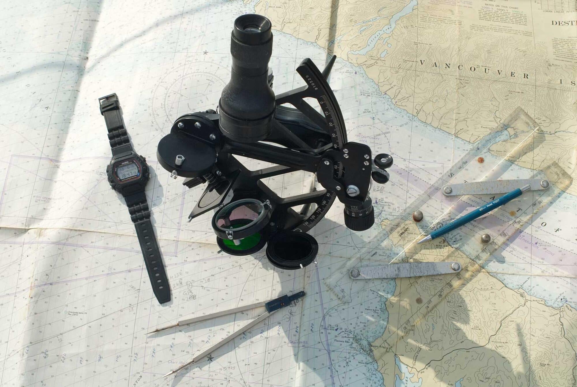
A complete celestial navigation kit includes a sextant, a chronometer or reliable quartz watch set to UTC, the current Nautical Almanac, sight-reduction tables, plotting sheets, dividers, pencils and calculation forms.
Accurate time is essential. Earth rotates through 15 degrees of longitude each hour. That equals 15 minutes of longitude every minute of time and 15 seconds of longitude every second.
The surface distance represented by a longitude error changes with latitude. Near the equator, a four-second timing error can move the calculated longitude by approximately one nautical mile, or 1.852 kilometres.
The navigator must check the watch before departure, record its error and monitor its daily gain or loss.
The Instrument Check Before Every Observation
The first task is to establish the sextant’s index error.
The observer looks at the horizon through both optical paths and moves the index arm towards zero. The direct and reflected horizons should form one continuous line. Any difference becomes an index correction applied during the calculation.
The sextant must also remain dry, protected from impact and kept away from rapid temperature changes. A bent frame or disturbed mirror can corrupt every subsequent observation.
For a Sun sight, the observer selects the correct shades, faces the Sun and brings its reflected image towards the horizon.
The instrument is gently rocked from side to side. The reflected Sun then traces a small arc. The observer places the lowest point of that arc on the horizon. This confirms that the sextant is vertical.
The observer calls “mark” at the moment of contact. Another crewmember records UTC to the nearest second. A single-handed navigator must read the time immediately after the sight.
Correct shades are essential. Direct observation of the Sun can cause permanent eye damage.
The recorded measurement is called sextant altitude, or Hs.
The Corrections That Produce the Observed Altitude
The raw sextant reading contains several predictable errors.
Index correction accounts for the instrument’s zero error.
Dip accounts for the observer’s height above the visible horizon. A person standing high above the water sees the horizon farther away and slightly lower than a person at sea level.
Refraction accounts for the atmosphere bending light. The correction becomes particularly significant when a celestial body is low above the horizon.
Semidiameter corrects observations made on the upper or lower edge of the Sun or Moon. Almanac calculations use the centre of the celestial body.
Parallax accounts for the observer’s position on the Earth’s surface rather than at the Earth’s centre. It has a major effect on Moon sights and a much smaller effect on stars.
After these corrections, the sextant altitude becomes observed altitude, written Ho.
A reliable fix begins with a reliable sight.
The Sight Reduction That Creates a Line on the Chart
The Nautical Almanac gives the Greenwich Hour Angle and declination of the observed celestial body for each hour of UTC.
Greenwich Hour Angle describes the body’s angular position west of the Greenwich meridian. Declination is comparable to latitude projected onto the celestial sphere.
The navigator begins with an assumed position close to the current dead reckoning position. Sight-reduction tables, such as Publication 229, then provide two results.
The first is computed altitude, written Hc. This is the angle at which the celestial body should appear from the assumed position.
The second is true azimuth, written Zn. This is the true bearing of the celestial body.
The navigator compares observed altitude with computed altitude:
Intercept = Ho − Hc.
One minute of arc represents one nautical mile, or 1.852 kilometres, on the Earth’s surface.
Suppose the corrected observed altitude is 42°18.6′ and the computed altitude is 42°12.2′. The difference is 6.4 minutes.
The intercept therefore measures 6.4 nautical miles, or 11.9 kilometres.
Observed altitude is higher than computed altitude, so the navigator plots the intercept towards the celestial body along its azimuth. A lower observed altitude produces an intercept plotted away from the body.
A line drawn at 90 degrees to the azimuth is the line of position. The yacht lies somewhere along that line.
The traditional memory aid is simple: Ho more, towards; Ho less, away.
One observation produces one line of position.
The Multiple Sights That Produce a Celestial Fix
Two lines from different celestial bodies can intersect and create a position fix. Three well-spaced observations provide a stronger result and expose a poor sight.
Nautical twilight offers the best opportunity for star navigation. The horizon remains visible while the brightest navigational stars and planets have appeared. The observer can take several sights in rapid succession and reduce them to a common time.
A useful selection includes bodies spread widely around the horizon. Three stars located in nearly the same direction create weak geometry and amplify observation errors.
The Sun can also provide several position lines during the day. A morning Sun line is plotted and advanced using course and distance travelled. A later Sun line can then cross it.
A meridian altitude around local apparent noon provides a relatively direct calculation of latitude. The navigator observes the Sun as it rises, reaches its maximum altitude and begins to fall.
The noon sight remains useful, although it gives less information than a properly developed series of lines. Longitude still depends on accurate time and further calculations.
Practical celestial navigation can place a well-trained crew within a few nautical miles of its true position. Clouds, haze, a distorted horizon, inaccurate time and poor observation technique can enlarge the error considerably.
Celestial navigation is suitable for crossing oceans, monitoring progress and approaching a broad landmass. It cannot provide the precision required for entering a reef passage or narrow harbour under uncertain conditions.
The Emergency Routine That Prevents Escalation
A GPS failure should trigger a structured response.
Confirm the yacht’s steering, electrical supply and communications. Identify which instruments remain independent. Preserve the last reliable position and start the manual plot.
Reduce sail when crew workload, visibility or traffic requires it. Post a dedicated lookout. Maintain a safe distance from land, shoals and traffic separation schemes.
The crew should preserve every independent instrument. A battery-powered compass, handheld VHF, radar, echo sounder and quartz watch may become more valuable than the main navigation network.
Keep accurate UTC even during several days of cloud. Continue the dead reckoning plot so that the next celestial observation begins with a credible assumed position.
The paper chart should show hazards, clearing bearings, safe depths, alternative ports and generous margins around the estimated track. A close nighttime landfall becomes an unnecessary risk when positional uncertainty remains high.
The skipper may need to slow down or heave to until daylight, improved visibility or a reliable fix becomes available. Progress has less value than control.
The Equipment That Must Be Ready Before Departure
A sextant stored aboard without training offers limited protection. The crew should practise Sun sights during ordinary passages and compare the calculated position with GPS.
Completed sight-reduction examples should remain with the equipment. The sextant should be adjusted regularly. The chronometer’s error and rate should be recorded.
A serious non-electronic navigation kit should include corrected paper charts, a magnetic compass with a current deviation card, a hand-bearing compass, independent UTC watches, pencils, dividers, parallel rules and a manual log.
Offshore crews should add a quality sextant, the current Nautical Almanac, the correct volumes of sight-reduction tables and waterproof calculation forms.
Backup electronics remain valuable when they have independent power and antennas. A handheld GNSS receiver stored in a protected container can survive a failure affecting the yacht’s primary network. It still depends on satellite signals, so it complements rather than replaces traditional navigation.
The Privilège Approach to Genuine Navigation Redundancy
Two chartplotters connected to one antenna, one network and one power supply provide display duplication. A single underlying failure can disable both.
Genuine redundancy separates position sources, power supplies, displays and methods.
At Privilège Marine, redundancy means that the yacht can continue operating safely after a component fails. The principle applies to propulsion, steering, energy, communications and navigation.
System accessibility also matters. The crew must be able to identify a failed connection, isolate damaged equipment and restore essential functions while at sea.
A bluewater yacht serves as both an ocean-going vessel and a home. A protected navigation area, clear sightlines, secure movement and manageable watchkeeping arrangements reduce fatigue. They preserve the crew’s ability to think clearly after hours or days of degraded operation.
Modern navigation has made ocean sailing more precise and accessible. Its convenience can hide the number of systems supporting a single position symbol on a screen.
Seamanship begins where convenience ends.
A crew that can preserve a course, maintain an estimate, read a coastline and recover its position from the sky remains capable when technology stops cooperating.